No Compass
8 May 2016
I love my Garmin: when walking or cycling it’s by far the easiest mode of navigation, and the way it reduces navigation to “following a line” is a great thing for safety and ease-of-use. But, no matter how usable, the majority of my navigation is still done with a map and compass. The next rung down on the sophistication ladder, however, still has some worth. A few times I’ve set off mapless on the bike, and had to navigate my way home using the sun, or the lie of the land. These techniques are often mentioned on survival websites, or in literature for mountain skills training.
Anyway, the point is that this article is about finding where North is in various situations.
This article is primarily written for those of us in the northern hemisphere, because that’s where I normally am. If you’re in the southern hemisphere, or even if you’re near the equator, then many of these methods won’t apply. Also, by “North” I mean “True” or geodetic north: that is, the actual top of the planet, rather than the top of your map or where your compass might point. This distinction is fairly unimportant if you’re navigating roughly around the UK, but the differences can be quite pronounced further north (for example, Iceland is 14° off).
There are three methods of navigating usefully here: the first group rely on direct observation of celestial bodies, computing direction from a known latitude and time. The second group use persistent effects of the sun’s motion, such as where moss grows or what receives the most heat. Finally, and a group of methods not covered by most of these articles, we have the human-designed elements: orientation of things such as churches and satellite dishes.
The Path of the Sun
Computing the sun’s path is old-school. It seems to be one of those areas of research that is so old it’s acquired its own lexicon. Basically, there are a number of effects that sum to explain the position of the sun relative to an observer on Earth:
- The Earth orbits the sun elliptically;
- The Earth’s equatorial plane doesn’t match its orbital one (except during an equinox);
- The Earth spins.
None of the effects above are stable over long periods of time too (for example, the Earth’s axis wobbles), but this document is about an intuitive understanding rather than absolute accuracy.
To compute the position of the sun you need two inputs: your position on Earth (a latitude and longitude), and the current date and time.
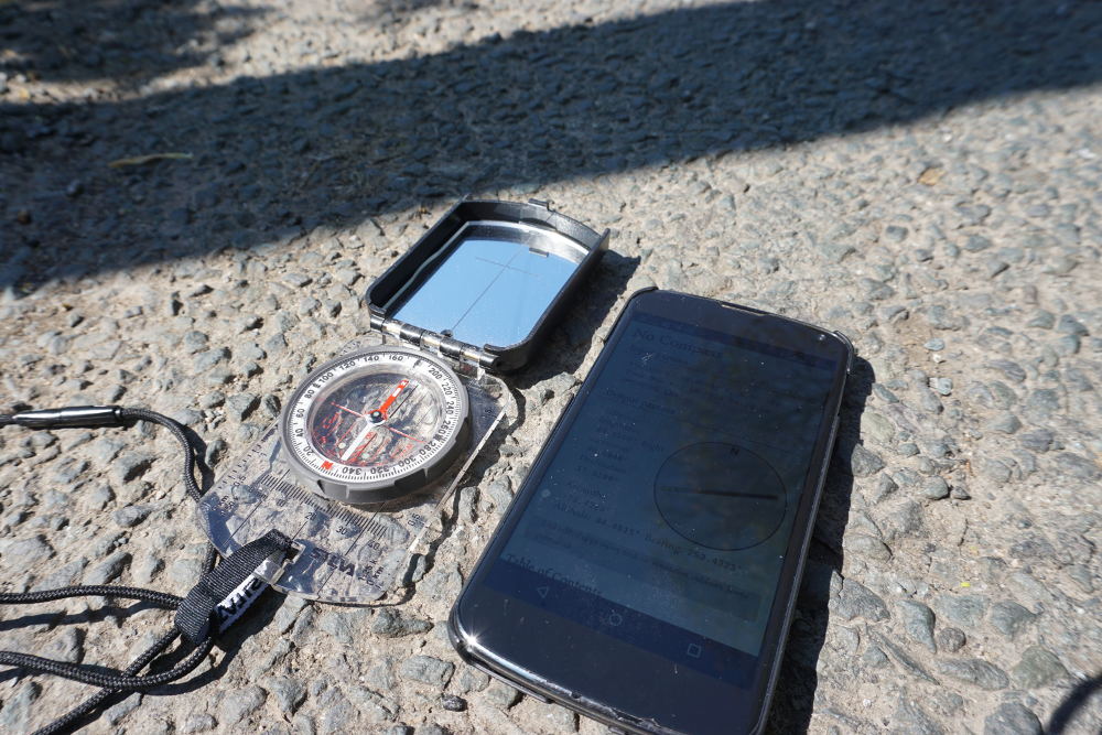
From these, we can compute the angle and inclination of the sun for an observer on Earth. The method is based on the equations at aa.quae.nlI originally built this as a live JavaScript calculator that read your browser’s location and clock. It seemed to work, but incorporated a bit of error: it was crudely tested by laying my phone in the road next to the shadow from a nearby telephone pole. Caveat emptor..
The Sun’s Position Relative to the Earth
The position of the sun relative to Earth is defined in terms of the ecliptic: the path we see the sun follow relative to the stars. This system represents positions relative to the plane of the Earth and Sun’s orbit, showing ecliptic latitudes and longitudes from that.
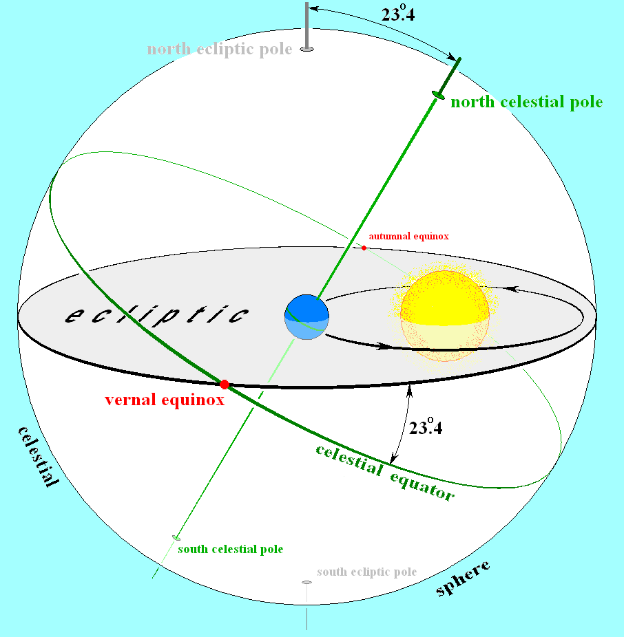
The plane in the image to the right is the celestial equator, and we can address our location relative to this. This is easy enough for the latitude (even though our planet’s axis is tilted at 23.4°), but the longitude requires some set zero point: for this we choose the perihelion of our elliptical orbit.

There are a couple of complexities here that I’m skipping: namely the elliptical nature of the Earth’s orbit, and the angle of the orbit relative to the ecliptical equator.
From the date, we derive the ecliptical longitude of the sun, which fixes its position along that path.
… Relative to the Equator
Next up we need to adjust for the Earth’s axis, which affects the apparent speed and path of the sun. For this, we use another coordinate system which is aligned to the equator of the Earth: latitude (termed declination) is measured relative to the celestial poles, and the longitude component (termed right ascension) is measured eastwards, with the March vernal equinox counting as zero.
It’s convention to represent right ascension as hours and minutes rather than degrees or radians. If you’re into measuring things relative to the stars (sidereal time), this comes in handy. For us, it’s just slightly annoying.
The equatorial coordinates of the sun are then described using its right ascension and its declination.
… Relative to You
The final coordinate system adjusts from the Earth’s equator to your position. We’re now talking about where to expect the sun in the sky, and this is specified in terms of the altitude and azimuth. Altitiude is expressed in degrees above the horizon, from 0° at the equator to 90° directly overhead. Azimuth is which way you face: 0° at south, 90° when facing west, etc.
To compute this, we need to know how far through the day we are, to take into account the Earth’s spin. This is done using the the hour angle, which is the amount the right ascension has changed since the Sun was last seen overhead.
Taking these things into account, you can find the sun at a given time and location by looking some number of degrees from South (the azimuth) at some angle above the horizon (the altitude). Together these equate to a compass bearing — feed your own latitude, longitude, and the time into the equations linked above and you’ll have it1.
But I Left My Sextant at Home
Well….fuck, I guess now you’re really lost.
Generally, sitting down to compute the above in the field is not an option. There are many ways of simplifying it, and these days it’s relatively easy to know the time. What about some rough estimates that don’t demand pen and paper, though?
We can use the lessons from the path of the sun to work out certain truths. For the Northern hemisphere, we can be sure that the sun passes to the South, rising in the East and setting in the West. This is only strictly true on an equinox, and most wrong at the solstices. Just how wrong is dependent on the season, and your latitude.
We can use this to make a quick-and-dirty estimation of direction based on time and hemisphere. For a vague guess, it’s worth remembering that the declination of the Earth’s axis is a full 23.4° — during the winter solstice in the UK, sunrise occurs closer to Southeast than South, likewise Northeast during summer. Reasoning like this forms the basis of the geometric methods listed here.
In addition to this direct observation, it’s possible to identify persistent effects on the landscape, both of the celestial motion (e.g. heating due to the sun on one side rather than the other) and of other long-term effects you might be aware of (e.g. prevailing winds). These second-order mechanisms form the basis for the heuristics listed here.
Geometric Methods
We may not have enough instrumentation to get the numbers but, in lieu of precise measuring devices, a bit of geometry can help. This is probably about as close as you’ll get without sitting down and doing some analogue of the maths in the first section.
Sun stick
This seems to be the most popular of the sun-based methods, and relies on a simple stick jammed upright in flat earth. Obviously, to use this the sun needs to be out, but it can also take quite a while compared to many others on the list.
The first observation is shadow length, which will be shortest when the shadow is pointing away from the equator. We can use the motion of the shadow itself, however, to plot a line east to west.
The basic gist is that we mark the position of the end of the stick’s shadow with a rock, wait a bit (at least fifteen minutes or so), and then mark the tip of the shadow again. As the sun moves East–West, the shadow cast by the stick swings West–East, so we can plot a line between these two marks to draw a rough idea of this.
The Watch Thing
This is a neat trick, and vaguely uses the hour angle calculations from our soiree into astronomy above, combined with the geometry of a watchface, to identify a given direction.
There are many guides available online showing you how to do this in detail, so I’ll be brief. In the northern hemisphere, South can be found by pointing the hour hand at the sun, and bisecting the angle between this and the 12-o’clock position on the watchface.
The Moon
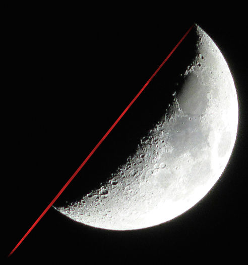
The moon is a great big rock thing in the sky, and follows patterns similar to the Sun’s. It is quite possible to use similar techniques as we did earlier to compute the position of the moon (and doing this will also help inform our knowledge of the tides, which might come in handy), but for the sake of brevity I will stick to the simplest method.
Looking up at the crescent moon, a line drawn from the top `tip’ of the crescent, through the lower tip, points South.
Pole Stars
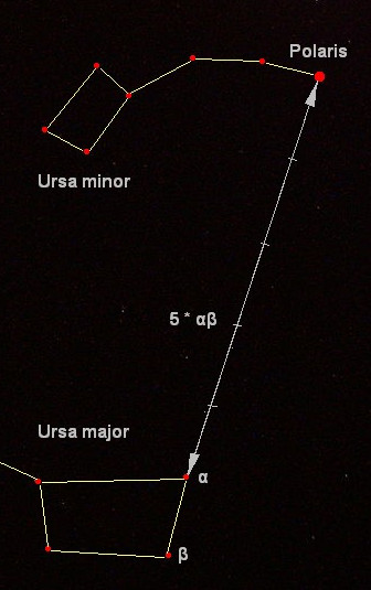
Polaris is remarkably bright, and sits at just over 89° declination, so lies North of just about everything. It can be found by seeking other constellations, perhaps most notably Ursa Minor (see right).
If you’re in the Southern hemisphere, the Southern Cross (Crux) can be used to identify south. It’s nowhere near as clear-cut, however, with a declination of -63°.
Heuristic Methods
Until now we’ve been using the geometry of the planets to reason about direction. These are accurate, but not always so accessible: it may not be possible to clearly see the sky, for example. The path of the sun is regular and long-term enough to have defined a number of other processes, which act as second-order indicators of direction, and there are a number of other long-term processes that define the landscape, such as weather patterns or deliberate human designs.
These signs often vary due to context, and their existence must be critically evaluated given knowledge of the landscape, location, and weather: most of the things listed here exist because of the effects of the Sun’s path, the topology of the landscape, or prevailing weather patterns. This list isn’t, and cannot be, exhaustive, but I’ve tried to scrape together the classics.
Growth of Organisms
Plants and animals love the sun, and, typically, dislike the wind. These effects can be seen in many ways, from the location of plants and animals in the landscape to their formation and behaviour. Often, these things will interact with other items in this article, due to the proximity of other landscape features, so bear in mind the causal mechanism when looking for signs.
Perhaps the most well-known feature is the growth of moss on trees. Moss, contrary to my little introductory paragraph, likes damp conditions, and so will prefer the northerly side of features such as trees and walls. Care must be taken to rule out dampness due to shelter that is caused by nearby features, by proximity to the ground, or by the surface itself.
The opposite of this is the tendency for plants to grow better on the sunny side of things. This includes cover from walls and trees, as well as changes in aspect (which we cover below in way more detail): a road following an east–west course will exhibit greener verges on one side, for example. There are also shorter-term effects: many flowers follow the sun throughout the day, and will bloom slightly earlier.
Trees, being large plants, also exhibit these patterns. They grow with denser foliage on the sunny side, and, when felled, exhibit rings that reflect this. Such behaviour, however, is complex and dependent on local factors: in leafy England, the south side shows enhanced growth, but the opposite is true in warmer climes with less available water.
Shadow and Aspect
Many things occlude the sun, and the effects mentioned above are also visible to some degree due to the lie of the land. This is often very apparent in mountainous regions: it’s possible to find snow on northern aspects of UK mountains late into the summer, and rocks leave little blobs of snow or wet patches on their north sides.
The exact nature of snow is complex, and it’s also possible to use the winds to inform knowledge about its distribution. If the snow is powdery, it will form patterns analogous to sand dunes and drift behind things. The behaviour of snow is complex, and I cannot claim to cover it all here.
When not snowy, dew and frost ‘shadows’ form on the north side of obstacles. This is apparent around small-scale features like trees, but also on whole mountains. Whole hillsides will remain damp longer into the day, and simply feel cooler to the touch. Small bodies of water will also dry faster where they are not sheltered from the sun.
This temperature differential also influences the growth of plants and animals. A meaningful summary of this would require far better knowledge of species than I can muster for this blog post, but I can hopefully rely on Gooley’s heuristic of finding broader-leaf, more energy-intensive plants on sunnier aspects.
Weather
Requires that you know something about the prevailing weather conditions or topology of the landscape. A little knowledge can go a long way here, as it often combines with other items on the list to offer a more complete picture of an effect.
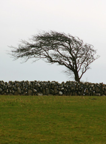
When reasoning about the weather, it pays to be aware of the timescale of the effect. Prevailing winds will distort trees and hedges, sometimes in a very extreme manner (left).
These longer term effects also influence weathering of landscape features and buildings, and influence the behaviour of others: the shelters at the summits of many mountains in the lake district are more developed (and, indeed, strewn with orange peel) in directions that shelter walkers from the typical gale.
Moving to shorter-term effects, the ripples in sand and snow form perpendicular to persistent winds, and direct observation of clouds scudding overhead (or distant rain) can be related to knowledge of current weather patterns.
Finally, the landscape itself influences the weather: clouds are pushed ‘up’ by hills, often forcing them to cool and condense. This can leave drier areas in the lee of hills, for example, the east of England is sheltered by the Pennines.
Human
All this stuff so far has been natural: the effects of the world as it formed organically over the millennia. Even the most remote parts of the British landscape, however, exhibit the signs of human habitation. Though it can be tempting to write these off as superfluous (after all, if you’re near people you can probably just follow signs or something), this is not quite the case: rural areas are very sparsely populated, and roads are usually the most boring route.
Perhaps the most obvious of the human factors is the orientation of churches. Christian churches place their altar at the East end, with their main entrance at the other. They are usually cross-shaped, with the head of the cross holding the altar: something that can make this a useful heuristic even when viewed from afar.
Many human features also interact with the weather very deliberately. Wind farms and weather vanes are obvious instances of this, both of which can illustrate wind direction when it is not apparent from ground level.
Both TV antennae and satellite dishes are oriented to face fixed geographic points. Using the former of these will probably require some rather specific knowledge, but the latter is simpler to remember: most TV satellites are geostationary, and there are a limited number of geostationary orbits available, all over the equator.
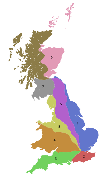
Finally, if you’re in sight of some road numbers, it’s worth noting how these are numbered. In the UK, roads are assigned a number starting with a digit that follows clockwise around london: starting with a ‘1’ by the Humber and becoming ‘9’ around Edinburgh.
Go and Explore
Using the knowledge here requires knowing a whole ton more about navigation than simply which way North lies, but it’s a good start. Whilst writing this article I came across one of Tristan Gooley’s books, which I heartily recommend as a more holistic source on that front.
In his book, Tristan offers the reminder that many of these methods could, and should, be combined in use. This is an important point: many of the heuristics above are quite unreliable or locale-specific, and moving through the landscape will require continual re-affirmation of direction.
As ever, the more you can combine information, the more useful it becomes. Setting off with a knowledge of the prevailing wind, or the orientation of a range of mountains, allows one to make an informed choice on which other heuristics to trust.
Additional to this, there is the suggestion that one should seek the mechanism through which these effects come about, and understand this prior to trusting it. The items listed in this article are intended as a first set of clues to look for in this endeavour, and there are many exceptions to their occurrence which must be understood if they are to be recognised in time to make a good prediction: sheltered regions may grow moss on all sides, for example, or nearby objects may be redirecting wind to reshape foliage.
Closing Remarks
This guide has been a rough introduction to the basics of identifying and using environmental methods for orientation. It’s by no means comprehensive, and there are a myriad other mechanisms which reveal something about the landscape (for example, there are many rules of thumb used by seafarers which do not apply on land), but which I have omitted due to their requirement for arcane knowledge (e.g. species of bird) or long-term observation.
Ultimately, the utility of these methods comes from experience applying them to situations you will encounter often, and a willingness to incorporate many sources of information into our navigation systems. In the future, I’ll not only be checking my map for directions, but also checking which side of my Garmin has moss growing on it.